
𐍆𐌴𐌹𐌻𐌰:Topographic Map of the UK - Blank.png
𐌼𐌹𐌺𐌹𐌻𐌴𐌹 𐌸𐌹𐌶𐍉𐍃 𐍆𐌰𐌿𐍂𐌰𐍃𐌹𐌿𐌽𐌰𐌹𐍃: 412 × 599 𐍆𐍂𐌹𐍃𐌰𐌷𐍄𐌹𐍃𐍄𐌰𐌱𐌴𐌹𐍃. Other resolutions: 165 × 240 𐍆𐍂𐌹𐍃𐌰𐌷𐍄𐌹𐍃𐍄𐌰𐌱𐌴𐌹𐍃 | 330 × 480 𐍆𐍂𐌹𐍃𐌰𐌷𐍄𐌹𐍃𐍄𐌰𐌱𐌴𐌹𐍃 | 528 × 768 𐍆𐍂𐌹𐍃𐌰𐌷𐍄𐌹𐍃𐍄𐌰𐌱𐌴𐌹𐍃 | 704 × 1,024 𐍆𐍂𐌹𐍃𐌰𐌷𐍄𐌹𐍃𐍄𐌰𐌱𐌴𐌹𐍃 | 1,750 × 2,545 𐍆𐍂𐌹𐍃𐌰𐌷𐍄𐌹𐍃𐍄𐌰𐌱𐌴𐌹𐍃.
𐍆𐍂𐌿𐌼𐌹𐍃𐍄 𐍆𐌰𐌾𐌻 (1,750 × 2,545 𐍀𐌹𐌺𐍃𐌴𐌻𐌰, 𐍆𐌴𐌹𐌻𐍅𐌰𐌷𐍃𐍄𐌿𐍃: 3.63 MB, 𐌼𐌹𐌼𐌴 𐌺𐌿𐌽𐌹: image/png)
𐌼𐌰𐌿𐍂𐌲𐌿𐍃 𐍃𐌺𐌴𐌹𐍂𐌴𐌹𐌽𐍃
| 𐍃𐌺𐌴𐌹𐍂𐌴𐌹𐌽𐍃 |
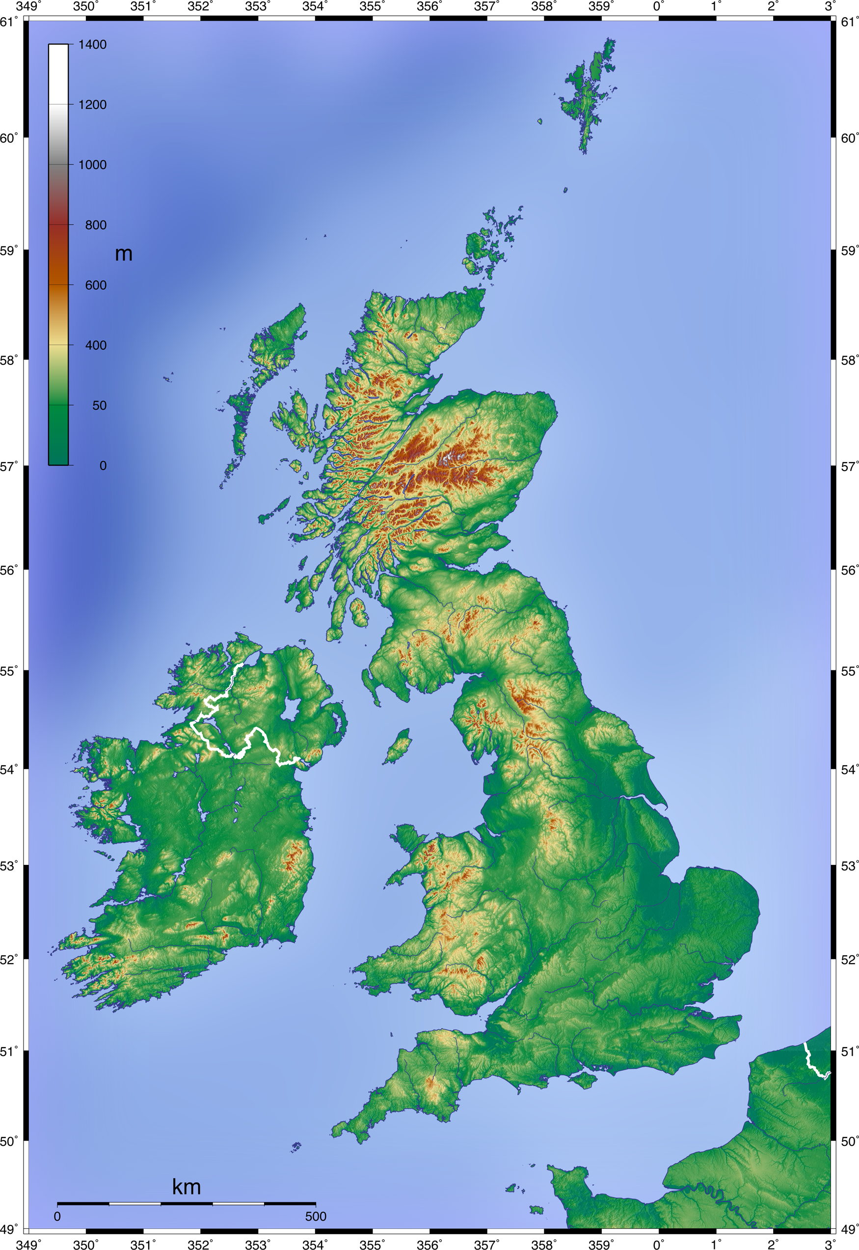
English: Topographic Map of the UK; Mercator projection, 1.750 x 2.545 px (blank w/out dots)
Deutsch: Topographische Karte Großbritanniens; Mercator-Projektion, 1.750 x 2.545 px (unbeschriftet, ohne Punkte) |
| Date | 11 𐌾𐌿𐌽𐌹𐌿𐍃 2008 (upload date) |
| 𐌱𐍂𐌿𐌽𐌽𐌰 | Own work by uploader, created with GMT and SRTM data |
| 𐌱𐍉𐌺𐌰𐍂𐌴𐌹𐍃 | Equestenebrarum |
| 𐌰𐌽𐌳𐌻𐌴𐍄 (𐌸𐌰𐍄𐌰 𐍆𐌰𐌾𐌻 𐌰𐍆𐍄𐍂𐌰 𐌱𐍂𐌿𐌺𐌾𐌰𐌳𐌰) |
Creative Commons Attribution 3.0 |
| Other versions |
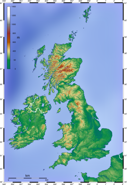
Derivative works of this file: Craven Pass through Pennine Mountains UK topographic map.gif
|


Licensing
I, the copyright holder of this work, hereby publish it under the following license:
This file is licensed under the Creative Commons Attribution 3.0 Unported license.
- 𐌰𐌽𐌳𐌻𐌴𐍄𐌰𐌽 𐌹𐍃𐍄 𐌸𐌿𐍃:
- 𐌳𐌿 𐌳𐌰𐌹𐌻𐌾𐌰𐌽 – to copy, distribute and transmit the work
- 𐌳𐌿 𐌱𐌻𐌰𐌽𐌳𐌰𐌽 – to adapt the work
- Under the following conditions:
- attribution – You must give appropriate credit, provide a link to the license, and indicate if changes were made. You may do so in any reasonable manner, but not in any way that suggests the licensor endorses you or your use.
𐍆𐌰𐌾𐌻𐌰𐍃𐍀𐌹𐌻𐌻
𐌰𐍄𐍄𐌴𐌺 𐌳𐌰𐌲/𐌼𐌴𐌻 𐌳𐌿 𐌱𐌰𐌽𐌳𐍅𐌾𐌰𐌽 𐍆𐌰𐌾𐌻 𐍃𐍅𐌰𐍃𐍅𐌴 𐌲𐌰𐌱𐌰𐌹𐍂𐌷𐍄𐌹𐌳𐌰 𐌹𐌽 𐌸𐌰𐌼𐌼𐌰 𐌼𐌴𐌻𐌰.
| 𐌼𐌴𐌻 | 𐌻𐌴𐌹𐍄𐌹𐌻𐌰 𐍆𐍂𐌹𐍃𐌰𐌷𐍄𐍃 | 𐍅𐌰𐌷𐍃𐍄𐌿𐍃 | 𐌱𐍂𐌿𐌺𐌾𐌰𐌽𐌳𐍃/𐌱𐍂𐌿𐌺𐌾𐌰𐌽𐌳𐌹 | 𐍅𐌰𐌿𐍂𐌳 | |
|---|---|---|---|---|---|
| 𐌽𐌿 | 13:07, 11 𐌾𐌿𐌽𐌹𐌿𐍃 2008 | | 1,750 × 2,545 (3.63 MB) | Equestenebrarum | {{Information |Description={{en|1=Topographic Map of the UK; Mercator projection, 1.750 x 2.545 px (blank w/out dots)}} {{de|1=Topographische Karte Großbritanniens; Mercator-Projektion, 1.750 x 2.545 px (unbeschriftet, ohne Punkte)}} |Source=Own work by |
𐍆𐌰𐌾𐌻𐌰𐌱𐍂𐌿𐌺𐌴𐌹𐌽𐍃
There are no pages that use this file.
𐌱𐍂𐌿𐌺𐌴𐌹𐌽𐍃 𐍆𐌰𐌾𐌻𐌴 𐌰𐌻𐌻𐌰𐌹𐌼 𐍃𐍄𐌰𐌳𐌹𐌼
𐌸𐍉 𐌹𐍆𐍄𐌿𐌼𐍉𐌽𐌰 𐌰𐌽𐌸𐌰𐍂𐌰 𐍅𐌹𐌺𐌾𐌰 𐌱𐍂𐌿𐌺𐌾𐌰𐌽𐌳 𐌸𐌹𐍃 𐍆𐌰𐌾𐌻𐌹𐍃:
- 𐌱𐍂𐌿𐌺𐌴𐌹𐌽𐍃 𐌰𐌽𐌰 fr.wikipedia.org
- 𐌱𐍂𐌿𐌺𐌴𐌹𐌽𐍃 𐌰𐌽𐌰 pt.wikipedia.org