
𐍆𐌴𐌹𐌻𐌰:Mauretania et Numidia.jpg

𐍆𐍂𐌿𐌼𐌹𐍃𐍄 𐍆𐌰𐌾𐌻 (3,509 × 1,383 𐍀𐌹𐌺𐍃𐌴𐌻𐌰, 𐍆𐌴𐌹𐌻𐍅𐌰𐌷𐍃𐍄𐌿𐍃: 494 KB, 𐌼𐌹𐌼𐌴 𐌺𐌿𐌽𐌹: image/jpeg)
𐌼𐌰𐌿𐍂𐌲𐌿𐍃 𐍃𐌺𐌴𐌹𐍂𐌴𐌹𐌽𐍃
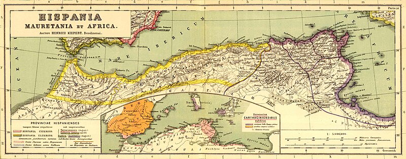
Bron: http://www.gottwein.de/latine/map/imp01_afr_nw.jpg
Autor: H.Kiepert, Atlas antiquus, Berlin (Reimer) o.J.
Licensing
|
This work is in the public domain in its country of origin and other countries and areas where the copyright term is the author's life plus 70 years or fewer.
| |
| This file has been identified as being free of known restrictions under copyright law, including all related and neighboring rights. | |
𐍆𐌰𐌾𐌻𐌰𐍃𐍀𐌹𐌻𐌻
𐌰𐍄𐍄𐌴𐌺 𐌳𐌰𐌲/𐌼𐌴𐌻 𐌳𐌿 𐌱𐌰𐌽𐌳𐍅𐌾𐌰𐌽 𐍆𐌰𐌾𐌻 𐍃𐍅𐌰𐍃𐍅𐌴 𐌲𐌰𐌱𐌰𐌹𐍂𐌷𐍄𐌹𐌳𐌰 𐌹𐌽 𐌸𐌰𐌼𐌼𐌰 𐌼𐌴𐌻𐌰.
| 𐌼𐌴𐌻 | 𐌻𐌴𐌹𐍄𐌹𐌻𐌰 𐍆𐍂𐌹𐍃𐌰𐌷𐍄𐍃 | 𐍅𐌰𐌷𐍃𐍄𐌿𐍃 | 𐌱𐍂𐌿𐌺𐌾𐌰𐌽𐌳𐍃/𐌱𐍂𐌿𐌺𐌾𐌰𐌽𐌳𐌹 | 𐍅𐌰𐌿𐍂𐌳 | |
|---|---|---|---|---|---|
| 𐌽𐌿 | 16:54, 3 𐌰𐍆𐍄𐌿𐌼𐌰 𐌾𐌹𐌿𐌻𐌴𐌹𐍃 2011 | 3,509 × 1,383 (494 KB) | Profburp | Meilleure définition. Extrait de la carte: Hispania, Mauretania et Africa. (with) Carthago. (with) Provinciae Carthaginiensibus subditae. Auctore Henrico Kiepert Berolinensi. Geographische Verlagshandlung Dietrich Reimer (Ernst Vohsen) Berlin, Wilhemlstr | |
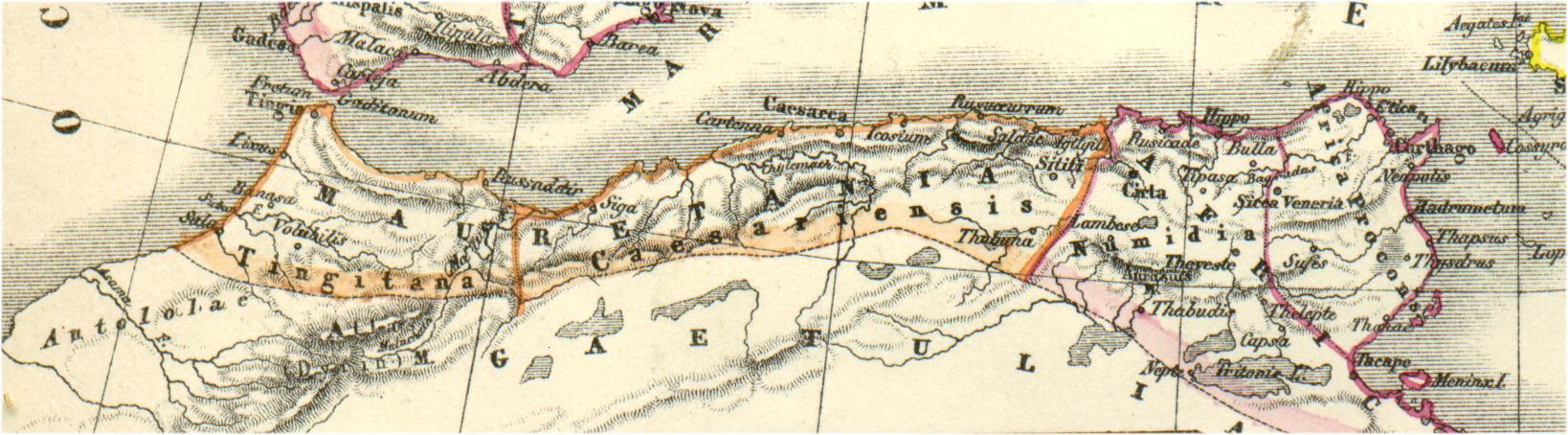
| 18:23, 13 𐌼𐌰𐌾𐌿𐍃 2006 | 1,638 × 454 (175 KB) | Rodriguillo | {{nl|Uit: H.Kiepert, Atlas antiquus, Berlin (Reimer) o.J. Bron: http://www.gottwein.de/latine/map/imp01_afr_nw.jpg Kaart met de ''provinciae'' Mauretania Tingitana, Mauretania Caesariensis en Numidia.}} {{es|Mapa de las provincias roman |
𐍆𐌰𐌾𐌻𐌰𐌱𐍂𐌿𐌺𐌴𐌹𐌽𐍃
𐌰𐍆𐍄𐌿𐌼𐌰 𐍃𐍉 𐍃𐌴𐌹𐌳𐍉 𐌻𐌴𐌹𐌽𐌺𐍉𐌸 𐌸𐌹𐌶𐍉𐌶𐌿𐌷 𐍆𐌴𐌹𐌻𐍉𐍃
𐌱𐍂𐌿𐌺𐌴𐌹𐌽𐍃 𐍆𐌰𐌾𐌻𐌴 𐌰𐌻𐌻𐌰𐌹𐌼 𐍃𐍄𐌰𐌳𐌹𐌼
𐌸𐍉 𐌹𐍆𐍄𐌿𐌼𐍉𐌽𐌰 𐌰𐌽𐌸𐌰𐍂𐌰 𐍅𐌹𐌺𐌾𐌰 𐌱𐍂𐌿𐌺𐌾𐌰𐌽𐌳 𐌸𐌹𐍃 𐍆𐌰𐌾𐌻𐌹𐍃:
- 𐌱𐍂𐌿𐌺𐌴𐌹𐌽𐍃 𐌰𐌽𐌰 am.wikipedia.org
- 𐌱𐍂𐌿𐌺𐌴𐌹𐌽𐍃 𐌰𐌽𐌰 ar.wikipedia.org
- الصفحة الرئيسية
- تيزي وزو
- ولاية أدرار
- ولاية سوق أهراس
- مستخدم:Tarawneh/test1
- موريطنية الطنجية
- يوبا الثاني
- المغرب
- طاغاست
- مستخدم:FShbib/نموذج الصفحة الرئيسية 4
- العصر الكلاسيكي بالمغرب
- ويكيبيديا:هل تعلم/قائمة/75
- مستخدم:ASammour/الرئيسية
- زوكابار
- مستخدم:حمزة الزاهر
- سوق أهراس
- مستخدم:Hcigerga
- حدود موريطنية
- ويكيبيديا:هل تعلم/قائمة شاملة
- مستخدم:FShbib/مشاريع/الصفحة الرئيسية 2020
- مستخدم:FShbib/مشاريع/الصفحة الرئيسية 2020 (2)
- مستخدم:FShbib/مشاريع/الصفحة الرئيسية 2020 (3)
- مستخدم:Ibrahim.ID/الصفحة الرئيسية
- مستخدم:FShbib/مشاريع/الصفحة الرئيسية 2020 (4)
- مستخدم:Aminebenamoor
- مستخدم:FShbib/مشاريع/الصفحة الرئيسية 2022
- مستخدم:لوقا/الصفحة الرئيسية
- 𐌱𐍂𐌿𐌺𐌴𐌹𐌽𐍃 𐌰𐌽𐌰 ary.wikipedia.org
- 𐌱𐍂𐌿𐌺𐌴𐌹𐌽𐍃 𐌰𐌽𐌰 ast.wikipedia.org
- 𐌱𐍂𐌿𐌺𐌴𐌹𐌽𐍃 𐌰𐌽𐌰 azb.wikipedia.org
- 𐌱𐍂𐌿𐌺𐌴𐌹𐌽𐍃 𐌰𐌽𐌰 az.wikipedia.org
- 𐌱𐍂𐌿𐌺𐌴𐌹𐌽𐍃 𐌰𐌽𐌰 be.wikipedia.org
- 𐌱𐍂𐌿𐌺𐌴𐌹𐌽𐍃 𐌰𐌽𐌰 br.wikipedia.org
- 𐌱𐍂𐌿𐌺𐌴𐌹𐌽𐍃 𐌰𐌽𐌰 ca.wikipedia.org
- 𐌱𐍂𐌿𐌺𐌴𐌹𐌽𐍃 𐌰𐌽𐌰 ckb.wikipedia.org
- 𐌱𐍂𐌿𐌺𐌴𐌹𐌽𐍃 𐌰𐌽𐌰 cs.wikipedia.org
- 𐌱𐍂𐌿𐌺𐌴𐌹𐌽𐍃 𐌰𐌽𐌰 cy.wikipedia.org
- 𐌱𐍂𐌿𐌺𐌴𐌹𐌽𐍃 𐌰𐌽𐌰 de.wikipedia.org
View more global usage of this file.