
𐍆𐌴𐌹𐌻𐌰:Isle of Angleseymap 1946.jpg

𐌼𐌹𐌺𐌹𐌻𐌴𐌹 𐌸𐌹𐌶𐍉𐍃 𐍆𐌰𐌿𐍂𐌰𐍃𐌹𐌿𐌽𐌰𐌹𐍃: 737 × 600 𐍆𐍂𐌹𐍃𐌰𐌷𐍄𐌹𐍃𐍄𐌰𐌱𐌴𐌹𐍃. Other resolutions: 295 × 240 𐍆𐍂𐌹𐍃𐌰𐌷𐍄𐌹𐍃𐍄𐌰𐌱𐌴𐌹𐍃 | 590 × 480 𐍆𐍂𐌹𐍃𐌰𐌷𐍄𐌹𐍃𐍄𐌰𐌱𐌴𐌹𐍃 | 944 × 768 𐍆𐍂𐌹𐍃𐌰𐌷𐍄𐌹𐍃𐍄𐌰𐌱𐌴𐌹𐍃 | 1,259 × 1,024 𐍆𐍂𐌹𐍃𐌰𐌷𐍄𐌹𐍃𐍄𐌰𐌱𐌴𐌹𐍃 | 2,517 × 2,048 𐍆𐍂𐌹𐍃𐌰𐌷𐍄𐌹𐍃𐍄𐌰𐌱𐌴𐌹𐍃 | 4,747 × 3,862 𐍆𐍂𐌹𐍃𐌰𐌷𐍄𐌹𐍃𐍄𐌰𐌱𐌴𐌹𐍃.
𐍆𐍂𐌿𐌼𐌹𐍃𐍄 𐍆𐌰𐌾𐌻 (4,747 × 3,862 𐍀𐌹𐌺𐍃𐌴𐌻𐌰, 𐍆𐌴𐌹𐌻𐍅𐌰𐌷𐍃𐍄𐌿𐍃: 4.73 MB, 𐌼𐌹𐌼𐌴 𐌺𐌿𐌽𐌹: image/jpeg)
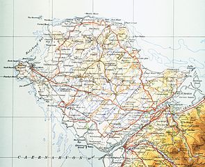
| 𐍃𐌺𐌴𐌹𐍂𐌴𐌹𐌽𐍃 | Map of Isle of Anglesey from 1946. Scale 0.25 inch to the mile 600DPI Sheet 4 "north wales and manchester" fourth edition |
| Date | |
| 𐌱𐍂𐌿𐌽𐌽𐌰 | OS Sheet 4 "north wales and manchester" fourth edition |
| 𐌱𐍉𐌺𐌰𐍂𐌴𐌹𐍃 | OS |
This work is an Ordnance Survey map over 50 years old, which is covered by Crown Copyright which in this case expires 50 years after publication. Ordnance Survey does however ask that they be credited and that the date of publication be given.
Any ancillary rights gained through the creation of the electronic version are granted as freely usable under any circumstances.
|
This work created by the United Kingdom Government is in the public domain.
This is because it is one of the following:
HMSO has declared that the expiry of Crown Copyrights applies worldwide (ref: HMSO Email Reply)
|
 |
𐍆𐌰𐌾𐌻𐌰𐍃𐍀𐌹𐌻𐌻
𐌰𐍄𐍄𐌴𐌺 𐌳𐌰𐌲/𐌼𐌴𐌻 𐌳𐌿 𐌱𐌰𐌽𐌳𐍅𐌾𐌰𐌽 𐍆𐌰𐌾𐌻 𐍃𐍅𐌰𐍃𐍅𐌴 𐌲𐌰𐌱𐌰𐌹𐍂𐌷𐍄𐌹𐌳𐌰 𐌹𐌽 𐌸𐌰𐌼𐌼𐌰 𐌼𐌴𐌻𐌰.
| 𐌼𐌴𐌻 | 𐌻𐌴𐌹𐍄𐌹𐌻𐌰 𐍆𐍂𐌹𐍃𐌰𐌷𐍄𐍃 | 𐍅𐌰𐌷𐍃𐍄𐌿𐍃 | 𐌱𐍂𐌿𐌺𐌾𐌰𐌽𐌳𐍃/𐌱𐍂𐌿𐌺𐌾𐌰𐌽𐌳𐌹 | 𐍅𐌰𐌿𐍂𐌳 | |
|---|---|---|---|---|---|
| 𐌽𐌿 | 16:10, 17 𐍆𐍂𐌿𐌼𐌰 𐌾𐌹𐌿𐌻𐌴𐌹𐍃 2009 | | 4,747 × 3,862 (4.73 MB) | Lirion | slight colour improvements |
| 19:11, 9 𐌼𐌰𐌾𐌿𐍃 2009 |  | 4,747 × 3,862 (4.28 MB) | Geni | {{Information |Description=Map of Isle of Anglesey from 1946. Scale 0.25 inch to the mile 600DPI Sheet 4 "north wales and manchester" fourth edition |Source=OS Sheet 4 "north wales and manchester" fourth edition |Date=1954 |Author=OS |Permission=none need |
𐍆𐌰𐌾𐌻𐌰𐌱𐍂𐌿𐌺𐌴𐌹𐌽𐍃
There are no pages that use this file.
𐌱𐍂𐌿𐌺𐌴𐌹𐌽𐍃 𐍆𐌰𐌾𐌻𐌴 𐌰𐌻𐌻𐌰𐌹𐌼 𐍃𐍄𐌰𐌳𐌹𐌼
𐌸𐍉 𐌹𐍆𐍄𐌿𐌼𐍉𐌽𐌰 𐌰𐌽𐌸𐌰𐍂𐌰 𐍅𐌹𐌺𐌾𐌰 𐌱𐍂𐌿𐌺𐌾𐌰𐌽𐌳 𐌸𐌹𐍃 𐍆𐌰𐌾𐌻𐌹𐍃:
- 𐌱𐍂𐌿𐌺𐌴𐌹𐌽𐍃 𐌰𐌽𐌰 cy.wikipedia.org
- 𐌱𐍂𐌿𐌺𐌴𐌹𐌽𐍃 𐌰𐌽𐌰 de.wikipedia.org
- 𐌱𐍂𐌿𐌺𐌴𐌹𐌽𐍃 𐌰𐌽𐌰 es.wikipedia.org
- 𐌱𐍂𐌿𐌺𐌴𐌹𐌽𐍃 𐌰𐌽𐌰 hsb.wikipedia.org
- 𐌱𐍂𐌿𐌺𐌴𐌹𐌽𐍃 𐌰𐌽𐌰 hu.wikipedia.org
- 𐌱𐍂𐌿𐌺𐌴𐌹𐌽𐍃 𐌰𐌽𐌰 ru.wikipedia.org
- 𐌱𐍂𐌿𐌺𐌴𐌹𐌽𐍃 𐌰𐌽𐌰 sv.wikipedia.org